1400 years passed, fourteen centuries, without any important urban nucleus developing on the banks of the River Gilão.
In archaeological digs or simple lucky finds, elements have been gathered, mostly ceramics and some construction materials, which have allowed us to confirm that the North-Western area of Colina de Santa Maria was once the site of a Roman village. The settlement may have been destroyed during the Islamic period, because the excavations carried out in this area do not reveal any traces of construction. It is quite possible that its name was villa frigida, the cold village which gave its origins to the actual place name Bela Fria.
During the Xth century AD, it is quite probable that the alcaria (village) Gilah grew up, the place name of which is derived from the same root as the Roman surname: IVLIANVS.
During the same era, perhaps at the end of the Xth or start of the XIth century, on the right hand bank of the river, a castle was built. This was aimed at protecting the ford of the river, which permitted transit between the two banks prior to the construction of the bridge in the XIIth century.
This fortress would have occupied the summit of the hill of Santa Maria, principally in the Southern part, and in the shadow of the walls, a population began to settle, which grew naturally and by the addition of people fleeing from the North as the neo-gothic conquest advanced towards the South.
From the materials collected during the excavations, it would seem that in the XIth century, the community residing in Tavira was already economically strong, and it is not impossible that they lived in a simple alcaria (village), unprotected from any attack carried out by land or sea.
This primitive defensive construction would only have enclosed part of the hill on which it was built. The Southern apex of the walled area would have contained the castle. From here, the wall would have extended to Calçada dos Sete Cavaleiros, where a piece of the wall is still visible in the Church of Santiago, facing this pavement. The Baptismal chapel (Capela Baptismal) of this temple could have been a tower belonging to this primitive defensive enclosure. The wall would have then continued to the area of the facade of the church, and occupied the slope existing between Rua D. Paio Peres Correia and Jardim Dr Jorge Correia, and on in the direction of the point where Porta do Postigo square meets the back of Rua António Viegas. From here it would have continued on to the Watchtower (Torre da Vigia), built by the Portuguese, surrounded the old Convento da Graça, currently an ENATUR hotel, climbed Calçada de Santa Maria to the area of the water tank, ending up once again in the castle, perhaps in the section of the wall which is still visible today next to the gateway.
Until further archaeological excavations allow us to confirm the veracity of this interpretation, the only help we have lies in a few studies of the topography of the modern city, some vestiges of construction, albeit significant, such as the Southern wall of Igreja de Santiago, and reconstructions of the ancient topography of the city.
Throughout the XIth century, with the conquest of the territories further North by the Christian kingdoms, and subsequent persecution, not only of followers of Islam, but also of Christian Arabs, more populations which were violently expelled from their houses and lands sought refuge in the tranquillity and exquisiteness of the South of the Iberian Peninsula.
During the XIth and start of the XIIth century, the city grew towards the river, with new boroughs springing up outside the walls, which gave shelter to landed inhabitants, as shown by the archaeological excavations carried out in this part of the urban nucleus. In this area, apart from living structures from those periods, objects have been gathered which demonstrate not only that the area was inhabited, but also that those who lived there had the possessions and habits of an opulent lifestyle. One example of this are the world-famous Vase of Tavira and the wealth of pieces gathered in the same archaeological context.
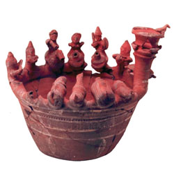
World famous Vase of Tavira (XIth century)
In the meantime, the power of Almoravide dynasty disintegrated and small kingdoms, known as taifas were created. These were states with independent policies through which they were alienated, not only from other Muslim kingdoms, but also from the emerging Christian monarchies, depending on their immediate interests.
At that time, Tavira was a republic, independent from any taifa and with a population which engaged in commerce and piracy between the coasts of the Iberian Peninsula and Africa. Knowing how to play with this situation which dominated the Islamic world, the Christian monarchs, successfully ensuring the neutrality of some, alliances with others, signing treaties with sovereigns from these little states in order to attack others, gradually amplified their territories towards the South. Among these Christian kings, Dom Afonso Henriques is of obvious interest to us. Having gained his independence from the kingdom of León in 1140, with a territory which hardly reached the Mondego, he resolved to create a stable border to the South, and to this end he directed his attentions to the valley of the Tagus, which he finally conquered in 1147, taking Santarém, Lisbon, Sintra, Almada and Palmela; economically flourishing fortified cities, with flourishing commerce and rich agriculture.
With the fall of these cities, one part of the population, generally the richer and more influential elements, moved towards the South, establishing themselves in the developed urban hubs on the Algarve’s coast. Between the Christian lands and the area where they now sought refuge, lay vast swathes of Alentejan heath, from whence raids by the Christian armies in the mountains of the Algarve would be launched.
Those who sought refuge there included Muslims, Christian Arabs, Jews and renegade Christians, forming a wealthy population but ill disposed to obeying an authority from beyond their territory.
The political situation of the Spanish Muslims and the unstoppable advance of the Christian armies so threatened Western Islam that the members of an emerging religious movement from Maghreb, the Almoadas, forced intense military intervention in the Iberian Peninsula.
The force of the Almoadans was so great that they conquered and reunified almost all of the peninsular South in no time, and even conquered Leiria. The principal danger lay in the North, and perhaps for this reason Tavira was not immediately affected by their intervention. It is true that chroniclers favouring the Almoadans referred to Tavira in not so flattering terms, classifying it as a home for pirates, infidels and renegades, however it took them several years to intervene in this city. The time which elapsed between the Almoadan invasion in 1146 and the fall of the city in 1167-8, was used by the inhabitants to fortify it, making it almost unbreachable.
As proven by excavations carried out in 1996, in the tier of houses in front of the Town Hall, boroughs were destroyed in the XIth and XIIth centuries, to make way for a strong wall, sometimes with a thickness of 4m and tom tall. This defensive wall was built in the so-called cyclopean taipa (horny wall), consisting of an amalgam of stone and lime mortar, of great strength, and with the faces covered in faceted stones, which were strongly bound to the same mortar, which served as a casing (see sheet 1). The outside was plastered and white-washed with lime with ingrained ochre.
This type of construction is usually attributed to the Almoadans, however Tavira could not have resisted the three ultra-powerful sieges by land and sea to which they were subjected if it hadn’t been heavily defended.
This wall, which, following the direction of the hands of a clock, would have started close to the Old Bridge, which itself was an Islamic construction, on the corner between Rua Gonçalo Velho and Praça da República, continued into the block in front of the Town Hall, until Arco de D. Manuel, where there once would have been a door. From here it would have continued on to the castle, where it intersected the Eastern facade. A section of the castle wall is still to be seen, jutting out of the wall of a more recent building.
The outline of the castle would have been practically identical to the previous one, descending from the castle to Igreja de Santiago and continuing along the primitive wall until Calçada de Santa Maria, where, instead of veering in the direction of the castle, as the former military work would have done, it continued on in the direction of the river, where, at what is now known as Largo do Parguinho, it turned in the direction of the river mouth and ended at Largo do Terreiro da Vila, now known as Rua Gonçalo Velho.
Here it continued until the point where we began this description; the place where Rua Gonçalo Velho intersects Praça da República.
This wall was to see the opening of a few entrances:
1st – The one that was replaced by Porta de D. Manuel and which gave access to the gulf which would have existed at what is now Praça da República;
2nd – another on Largo do Postigo, the narrowest door, through which, according to the chronicles, the proud monks, commanded by Dom Paio Peres Correia, would have gained access;
3rd – Porta da Bela Fria, an entrance of great importance, located as it was on the Roman road running from Baesuris to Balsa and Ossonoba and from here went North, to Alentejo.
4th – Still in the North face, the city would have had another door, namely the Pelames door, also situated on the Roman road. In the yard of the city, now Rua Gonçalo Velho was to see the opening of two further doors; the Terreiro da Vila door, on the aforementioned Roman road and the river;
6th – a connecting door, of which the chapel of Nossa Senhora da Piedade remains – clear Christianisation of one of the accesses to the city.
Only in 1167/68 was Tavira to surrender to the power of the Almoadans.
From here until the taking of the city by the knights of Santiago, the walled section was extended, with the construction of a new section of wall defending yet another extension of the city; this time to the West. This construction came out of the Western part of the castle and was to surround the entire zone which leads from Rua dos Escuteiros to the point where Rua da Porta do Postigo intersects with Rua dos Mouros. This wall, of which there still remains a large section behind Rua da Porta do Postigo, was built as a military taipa (horny wall), with clay mortar, lime and gravel, which gave it great strength, and was a building material which was typical of the Almoadas.
This religious political group was also responsible for the construction of at least four albarrã towers (mural towers), characterised as being outside the wall, to which they were linked by a sturdy bridge. These are the towers which are still standing in the castle, two in Bela Fria, which defended the port of the same name and the other adjacent to the bridge.
It is not known what the towers which have disappeared would have looked like, however, an analysis of the tower of the castle allows us to infer that they were military taipas, encased in stone. The connecting bridges would have been of cyclopean taipa.
The remains of another three towers are also known, linked to the wall, in military taipa, with a quadrangular layout. Two of these towers flanked the Pelames gate and the other was in the excavated building at Praça da República (BNU) and would have served to protect the door which predates Arco de D. Manuel.
It is also known that the walls of the city underwent renovation following the Christian conquest, Dom Dinis carried out work on the castle and Dom Fernando extended the boundary.
It is thought that the entire wall which passes behind the buildings on Rua da Liberdade, where, at the site of the Post Office there was once a tower, demolished in order to build that building, which was of Portuguese construction. Also from that period is the defensive work which, staring at Rua D. Paio Peres Correia, on the post office corner of which, inside a private building, a wall and an imposing tower were built, extends to Rua Miguel Bombarda to Largo dos Mouros and follows Rua dos Mouros to Rua da Porta do Postigo, where it joined the almoadan wall.
This wall, to which is attributed, a prior, a timeline which belongs to the Portuguese and on which several towers were built, such as the great oca tower, is completely encased by private houses or surrounded by courtyards which are very difficult to access, therefore any conclusion of an archaeological dig would be mere conjecture.
By the reign of D. Manuel, the Moors had already been completely dominated throughout the Iberian Peninsula, and the fight against islamicised population had shifted, more than a century prior to that time, to Northern Africa. In spite of Tavira not being a fortified city of great grandeur, the role which the city played as a base of support for the Portuguese campaign in Morocco and the commerce which was maintained in this area of Maghreb attracted a certain level of attention from the monarchy to the defensive restoration of the city. Apart from the gate which retains its name and which was aimed at facilitating communication between the area inside the walls and the surrounding area which was undergoing earnest expansion, the fortified section of the wall, erected in Rua de Trás dos Muros and swallowed up a substantial part of the military taipa towers, which, as has already been stressed, defended the Porta dos Pelames, was also from this period. Also of the same period is the section of the wall which borders the river, at Rua dos Pelames, and is still referred to as the Barbican. In this ante-wall, there is a door from this period which still opens, at the end of Rua de D. Ana, as can be affirmed from the bevelled stones which make up the pillars of the arch.